



By Dr. Lukas Müller, Ph.D. Atmospheric Sciences (Atmospheric Chemistry & Air Pollution). Researched and fact-checked against primary sources and reviewed by our editorial team. Last updated: October 8, 2026.
Ever notice that smog looks worst on calm, clear, cold mornings? Rain and wind clear air. A cold, still morning does the opposite. The cause is a weather feature called a temperature inversion, and it’s about to become far more relevant across the Northern Hemisphere as nights lengthen.
What a temperature inversion is
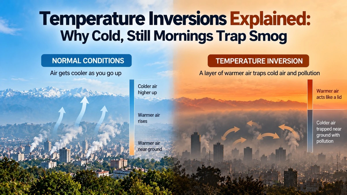
Normally the air gets cooler as you go up. Warm air near the ground rises, carrying pollution with it, and the pollution thins out in the vast sky above.
In an inversion, that order flips. A layer of warmer air sits on top of colder air near the ground. As the US National Weather Service explains, the cold air is trapped underneath. Warm air rises, but cold air doesn’t, so nothing mixes. Picture a lid on a pot. Whatever’s cooking underneath stays there.
Why autumn and winter nights are the problem
Inversions form most easily on clear, calm nights. Without clouds acting like a blanket, the ground loses its heat fast and chills the air touching it. Warmer air stays above. Add high pressure, which keeps the weather still, and the lid can last for days.
Valleys make it worse. Cold air is heavy and drains downhill, so it pools in basins and valley floors. Many European cities sit in exactly this kind of terrain. The European Environment Agency shows how this traps pollution close to the surface. Plains can suffer too, as long as the air is calm and the night is clear. That’s the standard setup for North Indian winters after the monsoon leaves.
Inversions don’t create pollution, they trap it
This point is easy to miss. An inversion doesn’t add a single particle to the air. Traffic, heating, industry, dust and farm fires do that. What the inversion does is stop the usual escape route upward. The same amount of pollution gets packed into a thinner slice of air, so your AQI climbs.
So if your city’s emissions are unchanged but the AQI doubles overnight, check the weather before blaming a new source.
How inversions end
- Sunshine: The sun warms the ground and the bottom layer, and the lid slowly lifts, often by late morning or afternoon.
- Wind: A stronger breeze stirs the layers together.
- A weather front or rain: A change in weather system breaks the pattern and washes out particles.
In stubborn winter cases, the lid doesn’t lift fully during the day, and pollution builds up day after day.
What this means for you
- Plan outdoor time for the afternoon. Air is usually cleanest after the inversion lifts, not at dawn.
- Don’t open all your windows on a cold, still morning. Ventilate in the afternoon instead.
- Check the forecast, not just the AQI. Calm winds and clear skies overnight mean the AQI will likely worsen.
- Cut your own emissions on those days. Skip the evening bonfire or wood stove if you can, and avoid burning rubbish.
Chart ideas
A simple side-by-side diagram would show two columns of air. In the normal case, temperature falls with height and smoke drifts upward. In the inversion case, a warm layer caps the cold air and the smoke is flattened underneath. A second chart could plot one city’s hourly PM2.5 across a calm, clear night to show the typical early-morning peak and the afternoon dip.
The bottom line
When air is still and the night is clear, pollution has nowhere to go. Learn to spot those conditions and you’ll know when to expect a bad-air morning.
Related reading: Ventilation index and calm-wind smog; Why AQI apps show different numbers; PM2.5 vs PM10.


